|
The Gulf Stream
|
Our goal is to drop a buoy equipped with
sensors off
the coast of Newfoundland in the Atlantic so it drift up
towards the
North. We can ask
ourselves how our Poseidon buoy will drift and
what are the parameters that explain the movement of
these bodies of water which will cause the
buoy.
1) Mechanisms of ocean currents
a)
The temperature of the
oceans
The Earth receives solar energy unequally: it is
not the same as that one
is at the pole or equator. The intertropical zone and receives as
much energy as the rest of
the world as depicted on the global annual average solar
radiation
Sunshine (en W/m²)
Just
as the atmosphere, the ocean has a great influence on global climate. In summer, when sunlight is most important, the
ocean surface warms. Through wind and wave action, and the
heat is redistributed on
a layer of about fifteen meters. The ocean, which warms more slowly than air, is still a
lot more time to cool. Thus, the ocean, which can be said that he has
a "memory" significantly higher than the atmosphere, stored for long periods of solar energy stored throughout the
summer. The surface ocean currents, such as the Gulf Stream, carrying heat from the equator to
the poles. It
is in areas of high latitude, when winter comes and the winds are more violent than the ocean cools while releasing its
heat. This imbalance sets in motion the atmosphere and
oceans which will rebalance the entire heat.
Map of the annual average temperature of ocean surface (in C°)
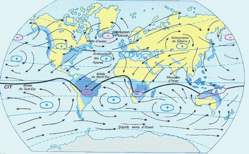
b) Wind as
a driver
The winds are the main factors of surface currents. They are governed by alternating low and high pressure with latitude, so
that the mid-latitudes are
the regions of westerly winds and the equator is
the headquarters of east winds (the Alizée).
Schematic of the atmospheric circulation at sea
("+" indicate areas of
high pressure and
"-" those of low
pressure.)
The winds are
able to develop the
mass movement of water up
to 800 meters deep. The surface of
the water can be animated bumps and hollows, thus our Poseidon buoy will be
subject to falls of
up to 10 meters in
height. It must therefore be
able to resist.
c) The difference in density of salt water
The winds have more influence after 800 m depth,
they can be engines of deep ocean circulation. These currents are based on
differences of temperature and salinity between the different oceans. This is the thermohaline circulation. The warm surface waters are responsible for
salt due to evaporation, which tends to make them more dense. In winter, during the formation of sea
ice, salt is preferably in
the residual water. Ocean water is then charged over denser salt, allowing the water to dive depths. The water depth in the poles back toward the equator: it
is the deep circulation.
Map
of the thermohaline circulation in the
oceans of the world
2) The Gulf Stream
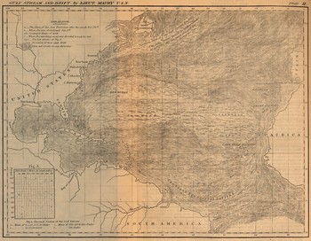
a) History
In 1513, Spanish navigator Ponce de
Leon remarked that off Florida's ships were constantly swept away by an
ocean current of warm water from the Caribbean Sea. He did
not know he had, unwittingly, to
discover a permanent ocean currents are
most important: the Gulf Stream. His discovery remained unresolved for more than two hundred and fifty years and only after the work of Benjamin Franklin, consisting of a
series of temperatures taken across the
ocean, thus defining the limits of
the current, that Gulf Stream's existence was acknowledged. He later established a
hydrographic chart of
this current to indicate the seamen the means to
use it during their voyage.
Navigation map of Newfoundland to New York representing the Gulf Stream - Designed in
the eighteenth century
Today the existence of the
Gulf Stream has been proven and is considered by many scientists. A
multitude of hypotheses have been made about her. It is therefore pertinent to ask how the oceanic phenomenon is
taking place, works, influences the climate and
how it may evolve in the
coming years.
b) Geography and traffic
The Gulf Stream was
born on the east coast of the
United States of America, off
the coast of Florida and one branch runs to
the Atlantic Ocean to the Greenland, Iceland and Europe. We know its
dimensions: 80
to 150 km wide and 650 to
1200 meters deep.
The Gulf Stream comes from the junction of two
streams: one
hand the North Equatorial Current,
coming from the African coast, on
the other hand, the Caribbean Current, which originates in the
South Atlantic and the Caribbean by bypassing the Gulf of
Mexico. High winds are moving equatorial waters of the Caribbean region. Since it is
warm and there is
not much rain, the waters are warm and
very salty. These masses of
warm water and salt become a
broad trend that took over the North Atlantic. Despite the fact that its water is very salty, this current remains on
the surface because it is also very hot. The Gulf Stream then crosses the Atlantic and
warms on its way the sides of the Western Europe bypassing it to go
up north. Arrivals in
the North Atlantic,
its waters begin to cool. And so, to a
temperature, they are much saltier than the surrounding waters. So they plunge to
the bottom of
the ocean.
We
will focus on the northern part of
the Gulf Stream.
 
Course of the
Gulf Stream in the Atlantic Ocean
c)
What is the utlity of the Gulf Stream?
The Gulf Stream is
a source of heat playing a key
role in the mild and pleasant climate of
Europe. Through the "North Atlantic Drift", the ocean current from the tropics of Mexico,
warm the front northwest of
Europe. Indeed, without the Gulf Stream, western Europe would experience the same climate as Canada, a climate of
both continental and
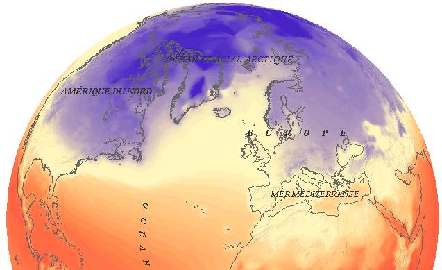
polar. The following map shows one
way the indisputable influence of the
Gulf Stream on the European coast.
Map of
atmospheric temperature in January
There is, as before, a
big difference between Western Europe and
Canada, however, two
regions at
the same latitude. The influence of the Gulf Stream on the European climate therefore appears to be important and even indispensable to
the lifestyle to
which the French are accustomed.
d) And if
he was not there?
The disappearance of the
Gulf Stream has been proposed by
scientists, who estimate it at less than 200
years. There were several assumptions made about the consequences of
the disappearance of the sea
current.
Indeed, the temperature has risen 0.6
° C in
100 years, the
Earth's surface and melting glaciers caused the increase in sea
level. The melting of glaciers is causing a flow of fresh water in
this region. If ever this contribution were to be too
large, then the thermohaline circulation could no longer do and the Gulf Stream could disappear. Indeed,
a large freshwater input would decrease the
differences in water density between the Arctic Ocean and Norwegian Sea. The place of diving cold water and salt would be left in the
Azores and the Gulf Stream should fall back on itself more gonna beyond the Azores.
For some, the currents of
the North Atlantic may have lost 30% of their strength by 2100, allowing colder winters in northern Europe which does not,
however, masks the current warming in
Europe.
|
|
|